Loading
![]()
![]()
A team of researchers led by Arthur Rodgers, Lawrence Livermore National Laboratory (LLNL), performed fully deterministic broadband (0-4 Hz) high-performance computing ground motion simulations of a magnitude 7.0 scenario earthquake on the Hayward Fault (HF) in the San Francisco Bay Area of northern California using the HPC systems Cori and Quartz at LLNL. Simulations consider average one-dimensional (1D) and three-dimensional (3D) anelastic structure with flat and topographic free-surfaces. The 3DTOPO case models the domain utilizing the 3D USGS Bay Area geologic/seismic model, a realistic fault geometry, and a topographic free surface. The simulation included mesh refinement and required 15 billion grid points and ran on 2400 nodes (86,400 cores) for about 18 hours total for a total of 1.5 million core hours. Ground motion intensity measures (GMIM’s) for the 3D model display dramatic differences across the HF due to geologic heterogeneity, with low wavespeeds east of the HF amplifying motions. The median GMIM’s agree well with Ground Motion Prediction Equations (GMPE’s), however the 3D model generates more scatter than the 1D model. Ratios of 3D/1D GMIM’s from the same source allow isolation of path and site effects for the 3D model. These ratios show remarkably similar trends as site-specific factors for the GMPE predictions, suggesting that wave propagation effects in our 3D simulations are on average consistent with empirical data.
Rodgers, A. J., Pitarka, A., Anders Petersson, N., Sjogreen, B. & McCallen, D. B.2018. Broadband (0-4 Hz) Ground Motions for a Magnitude 7.0 Hayward Fault Earthquake with 3D Structure and Topography. Geophysical Research Letters, 45. https://doi.org/10.1002/2017GL076505
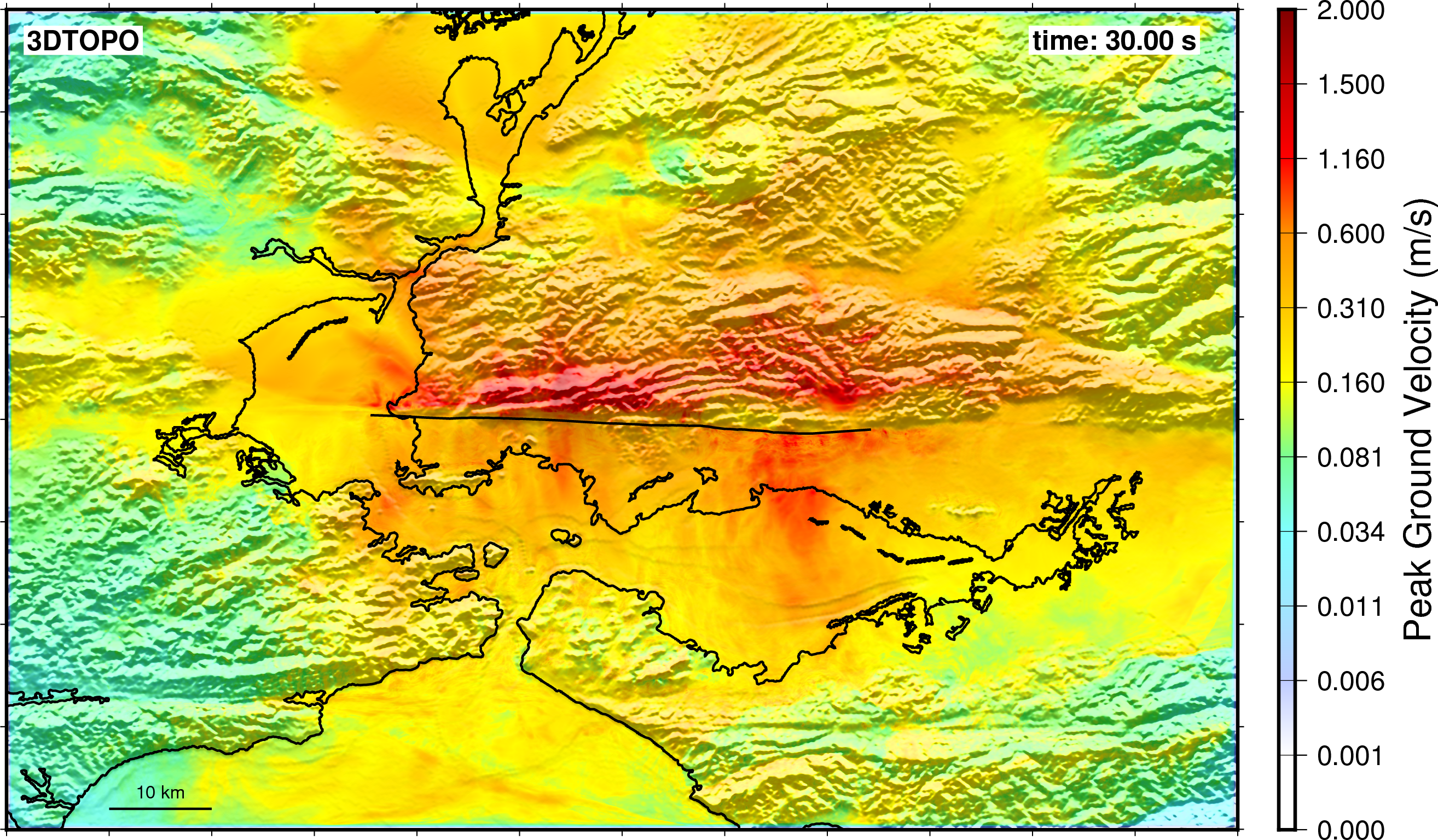
Peak ground velocity for high-performance computing simulation of a magnitude 7.0 earthquake Hayward Fault (black line), eastern San Francisco Bay Area, northern California. Simulation 3DTOPO models the domain utilizing the 3D USGS model with a topographic free surface. The simulation resulted in ground motions resolved to 4 Hz.
See Artie Rodgers on ABC news and this simulation using SW4.
Pssst - see if you spot the CIG product placement!